|
||
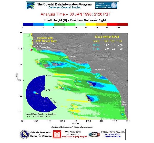
Original COMPAS Vision StatementScientific ThemeThe Center for Observations, Modeling and Prediction at Scripps (COMPAS), formed as a concerted and inter-disciplinary effort in numerical modeling, is intended to help lead the institution into the future of ocean research. The initial effort is focussed upon physical processes and phenomena in the ocean and the atmosphere. However, our long-term approach is inter-disciplinary and biological and chemical aspects will be addressed with increasing emphasis as COMPAS evolves over the next few years. In particular we envision substantial effect towards understanding CO2 sequestering in the atmosphere and the ocean and chemical processes in the atmosphere, as well as the effects of biology on the physical state of the ocean. Knowing the physical state of the ocean has substantial inter-disciplinary implications, for example in understanding the earth's angular momentum and improving measurements of the time-varying component of the earth's gravity field. Although ocean/atmosphere modeling centers already exist both in the U.S. and abroad, the anticipated effort at SIO will be unique in its intimate link to well developed, aligned activities in ocean and atmospheric observations, theoretical studies, and environmental prediction. To exploit these capabilities, COMPAS is designed to use large oceanographic data sets jointly with ocean and coupled ocean-atmospheric models to enhance simulation of the observed processes. This will lead to a better understanding of the time-evolving basin and coastal ocean circulation and its consequences, including those upon ocean-atmosphere interactions and climate, and ultimately upon the medium-range and longer predictability of regional and global atmospheric models. Given the fundamental difficulties of existing numerical models in simulating processes associated with ocean boundary layers, the areas in which COMPAS effort will be most immediately fruitful for SIO and the wider oceanographic community are observing, modeling and improving the theory of ocean boundary conditions ranging from small-scale boundary mixing and momentum transfers at the bottom and lateral boundaries, to large-scale air-sea interaction on climate scales. Although those issues cut across a wide range of disciplines and space and time-scales, they are organized around a common kernel of a numerical modeling activity and require a strong expertise in both numerics and physical understanding. Participating modelers will have the opportunity to extensively test their results because they will have direct access to detailed observations and meta-data sets that exist and are continuously being generated here at SIO and elsewhere. As a collaborate benefit, observationalists will have the opportunity to take advantage of the numerical expertise and numerical simulations while attempting to draw physical conclusions from the usually regional and sparse data, and also in planning future fieldwork. The Scope of the EffortThe new modeling initiative will build upon existing elements of data analysis, theory and model-data synthesis. Approximately 15-30 research scientists and faculty will be involved in this cross-divisional effort. To help link ongoing activities at SIO, critical gaps are now being filled through three new hires of experts in numerics and ocean dynamics, in coastal and small-scale modeling, and in large-scale atmospheric modeling. A fourth hire next year will augment the activity by adding an expert from a related field, which could involve biological-physical modeling, direct numerical simulations of wave breaking, bottom boundary layer dynamics and other small-scale processes, or atmospheric forecast improvements. The new COMPAS hires will strengthen our capacity to improve circulation models, algorithmically and numerically and will provide important connections between the broad range of theoretical and observational researchers already at SIO. Involved ElementsThe initial COMPAS thrust initially builds upon expertise in existing oceanic and atmospheric disciplines at CCS, CRD and PORD. The involved elements include:Observationalists: (in situ and remote sensing): SIO has a long-standing role in the development and employment of ocean instrumentation, regionally in process-oriented studies and on the large climate oriented scale. Data sets commonly include observations from autonomous Lagrangian drifters, moored instruments, and hydrographic measurements. More recently remote sensing methods, including acoustic techniques in the ocean and satellite-based sensors have found applications ranging from small, coastal scale to large, global-scale studies. Theoreticians: Theoretical studies are numerous and include recent investigations of intrinsic climate variability and small-scale structures in the ocean planetary boundary layer. Model analyses in the ocean and atmosphere: There are several ongoing process-oriented studies at SIO which either use output from models run at other institutions, or which use the models developed at other institutions. Those activities include simulations of near shore and regional surface gravity wave fields, the California Current System, the equatorial Pacific circulation, and global coupled ocean-atmosphere models. State Estimation: Recently SIO gained significant visibility in ocean state estimation activities by leading a national NOPP-funded activity in ocean state estimation with consortium partners at MIT and JPL. This activity is essential for optimizing the use of ocean observations in studies of the ocean circulation and its relation to atmospheric variability. It will play an important role in the anticipated modeling and data synthesis activity. Forecast Research SIO has a broad base of existing programs in modeling, diagnostics, and prediction that aim to identify coupled land-atmosphere-ocean linkages, develop global to regional climate prediction methodologies, validate and quantify regional climate impacts, predictability and uncertainty, and to develop a framework for representing cloud, aerosol and chemical processes and their related climate forcing for the prediction of global and regional climate changes. Educational and Visitor ProgramA strong educational component in modeling and ocean state estimation is part of COMPAS, and COMPAS scientists will provide lectures and labs in numerical modeling and data assimilation in physical oceanography and climate research. Additionally, COMPAS will build up an active visitor and exchange program, to exploit existing relationships with individuals at other institutions and agencies. COMPAS should participate in a new initiative at UCSD to create a MS and PhD program in scientific computing which currently is in its planing and implementation phase. An ongoing discussion is designing a joint SDSC/SIO postdoctoral program in environmental computing. Links accross campusBecause COMPAS is a cross-divisional initiative involving both observations and models, a major element of the anticipated modeling activity will be centered in Nierenberg Hall were it will be located among existing groups concerned with large-scale/climate observations and modeling. In addition, the activity will include distributed center elements with a significant small-scale coastal observational and modeling activity taking place in CCS and with model and computer experts located as well in other groups where future activities are envisioned to grow (e.g., Biology, Chemistry, Geophysics, etc.). To avoid becoming entangled in technical computer issues and overburdened by infrastructure demands, COMPAS has strong ties into SDSC and UCSD Computational Science Departments. At the same time we are pursuing other collaborations with the UCSD campus where activities in visualization and biology can substantially benefit our effort. Computational SupportThe long term success of an SIO modeling effort will depend crucially on the computing resources presently available, and a major effort in the near future will be to secure funds for hardware purchase/support. Our plan anticipates future support from private donors to ignite a longterm activity that will subsequently become self-supporting through federal grants. COMPAS will promote closer and more productive cooperation within SIO, with the SDSC and the anticipated CAL IT2 framework that is being pursued currently and that might lead to a CAL IT2 computational satellite on the SIO campus. The computing infrastructure that is envisioned will clearly benefit existing data and modeling activities at SIO, as well as new elements that evolve over the next decade. Initial COMPAS ProjectsThe COMPAS modeling activity is firmly embedded in ongoing activities which include two NOPP grants for large-scale observations using modern float technology (ARGO) and a new activity on ocean data assimilation. The coastal data information program continues to use a combination of observations and numerical models to produce real-time estimates of surface gravity wave conditions in California. A recently funded ACPI Pilot project, to produce improved global climate change simulations, initialized by constrained ocean model results, and projected onto regional circulation and water resources over the western United States, is another component that might develop into an ongoing program. The Experimental Climate Prediction Center, the California Applications Program, and the CORC are other ongoing NOAA funded activities may become part of the COMPAS activity. Here we summarize several Initial COMPAS activities:Coastal and small scale modeling: The computational requirements of coastal science are growing rapidly owing to the increasing complexity of both observations and numerical simulations, and scientists using the present CCS computer facilities are increasingly hitting computational stops. Field studies (dense arrays of current meters in the surf zone and on the shelf, ADCPs, coastal radar current mapping systems) increasingly yield detailed data sets that require very high resolution numerical modeling both for data assimilation and for dynamical interpretation. Future plans include the incorporation of seas generated by local winds, as well as remotely generated swell, in the model. Executing real-time operational runs will require both improved numerical algorithms and increased computational power. Rationally relaxing the delicate sequence of approximations leading to the modified KDV equation as a description of shoaling internal waves is an increased computational load. Observationally-based, real-time wave forecasts of waves and circulation use assimilation methods that require iterative runs of extremely high spatial resolution (10's of meters) models over regions spanning several 100 km (see figure). Rationally relaxing the delicate sequence of approximations leading to the modified KDV equation as a description of shoaling internal waves is an increased computational load. Modeling of wind-generated and internal waves in the southern California Bight is one of the important applications of the coastal COMPAS component.
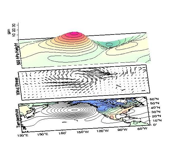
Future generations of coupled bio-physical and fluid-sediment interaction models require many more model runs that purely physical models in order to span a realistic range of environmental scenarios. Many of these needs will be met through COMPAS. Climate Modeling: Climate modelers at SIO, like most such groups in the United States are constantly struggling to obtain adequate computing resources. The SIO climate group has key simulation and forecast model codes are available and being run for both global and regional configurations, including global coupled atmosphere/ocean (Figure 2 illustrates the atmospheric circulation, winds and ocean temperature in the Pacific in an experiment to understand decadal variability over the basin), ocean basins, global atmosphere, regional atmosphere and land surface hydrology. However, in many cases the scope of the experiments permitted by available computing cycles is limited. For example, global modeling groups in Europe have access to dedicated supercomputer resources and can run, in a few days, a several hundred years compiled model integration, which will take us a year to accomplish. Towards a solution to this shortfall, we will pursue a multi-pronged strategy, which includes securing local mid-level computing and storage/retrieval as well as remote computer center super-computing and massive storage capabilities. It appears that a cost effective solution is dedicated computing platform(s) that are not necessarily latest generation, but ones that are under the direction of this local SIO group and thus can be run exclusively for specific modeling problems. Low maintenance cluster, similar to the one being prototyped by the ocean assimilation group appear desirable expertise in configuring, running, and maintaining these clusters is available at SDSC.
>Figure 2: The atmospheric expression of the North Pacific Oscillation. Bottom: wintertime temperature anomalies, showing cooler than normal conditions over North America. Middle: wind stress anomalies, showing increased surface flow from the Arctic. Top: geopotentialheight anomaly at 500 mb. Ocean State Estimation: The ocean is changing vigorously on a wide range of time and space scales. This variability leads to substantial problems in observing and modeling (simulating) the rapidly changing flow field, the ocean's temperature distribution, and more generally the consequences of those changes for climate. Among the goals of the present ocean and climate research are therefore to measure, understand, and eventually predict these variations by combining ocean data and ocean models. The purpose of data assimilation is to obtain by combining ocean observations with state-of-the-art ocean circulation models, an analysis of the time-varying ocean that is more complete and better than the information from either of them alone. This model-based synthesis and analysis of the large-scale ocean data set will enable a complete (i.e., including aspects not directly measured) dynamical description of ocean circulatio, such as insights into the natures of climate-related ocean variability, major ocean transport pathways, heat and freshwater flux divergences (similar for tracer and oxygen, silica, nitrate), location and rate of ventilation, and of the ocean's response to atmospheric variability.Data currently employed in ongoing optimization procedures include absolute and time-varying altimetry, monthly mean sea-surface temperature data, time-varying surface forcing fields, as well as monthly mean temperature and salt fields. To bring the model into consistency with the observations, the initial potential temperature and salinity fields are modified, as well as the surface forcing fields. Changes in those fields (often referred to as ``control'' terms) are determined as a best-fit (in a least-squares sense) of the model state to the observations and their uncertainties over the full data period. A few representative results are summarized in Figs. 1 and 2 which have been obtained as part of the NOPP-funded ECCO project 1.
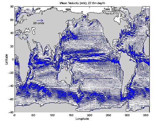
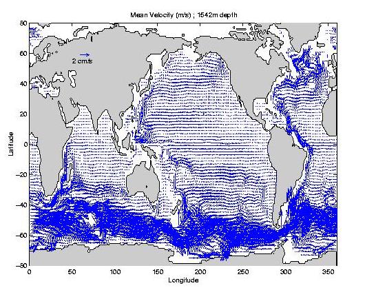
Figure 3: The estimated 6-year mean velocity field at 27 and 1542 m depth shows all major current systems. But with the low model resolution, they are necessarily overly smooth
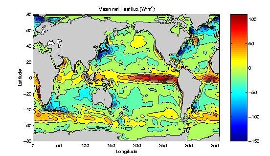
Figure 4 The mean net surface heat flux field as it results from the optimization is displayed in the upper panel. Its mean change relative to the prior NCEP fields is provided in the lower panel. All resulting modifications of the net NCEP heat fluxes (of the order of 20 W m-2 over large parts of the interior oceans and 80 W m-2 along the boundary currents) are consistent with our prior understanding of NCEP heat flux errors. |
||